I am embarrassed I made that title so Berkeley-esque… The Powerful Statement: Made More Dramatic by the Colon and Following 6 Words...
all those guilty of such things, you know who you are. I almost want to slap myself for it, but figured this is one of those occurrences I must make known in a public cry for help.
all those guilty of such things, you know who you are. I almost want to slap myself for it, but figured this is one of those occurrences I must make known in a public cry for help.
To make a long story short, much of Holland is below sea-level (in-case you haven't gathered that is why I am here) and a lot of the parts not below sea-level are still subject to flooding from rivers. Therefore, flood defences are a very strong national interest (unlike the United States for many reasons).
Here are mostly photos from the field trip I took out to see the barriers over a couple of days in Zeeland and elsewhere of the Deltawerken, the Delta Works Projects. I will avoid going into too much detail (if you want it, email me or wait for my report) so I’ll just show the pics and include a few basics. Delta” refers to the Delta of the Rhine-Meuse (Maas)-Scheldte rivers. For more details online, check out http://www.deltawerken.com/
Here are mostly photos from the field trip I took out to see the barriers over a couple of days in Zeeland and elsewhere of the Deltawerken, the Delta Works Projects. I will avoid going into too much detail (if you want it, email me or wait for my report) so I’ll just show the pics and include a few basics. Delta” refers to the Delta of the Rhine-Meuse (Maas)-Scheldte rivers. For more details online, check out http://www.deltawerken.com/
MESLANTKERING in Hoek van Holland.
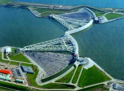
The suffix “kering” means “barrier” in Dutch. It… was… huge… (you will notice a theme). Sadly the photo doesn’t do it justice, but here is Matthijs in front of it to give you kind of an idea. And no, I didn't fly my heli-overhead to get the shot, I borrowed it from online.

(I did take this one though)

This gate is open now, but closes off the harbor (haven in Dutch) to the sea when there is a storm surge, (when the water level rises up very high as a result of a storm/heavy winds) or when they decide to test it (this Saturday) in order to make sure it will work when it counts (as in, during a surge).
Apparently they used a crappy grade steel when initially constructing it which means they have more maintenance than they would like. Costly, but they will still do it due to safety.
Apparently they used a crappy grade steel when initially constructing it which means they have more maintenance than they would like. Costly, but they will still do it due to safety.
Here is a video of the barrier with awesome dramatic music to accompany.
Matthijs (pronounced: Ma-tie-us/Mathias) is a kind, kind, and really smart man. I was put in touch with him by one of my professors from UC-Berkeley. He is a risk-management consultant/”expert” for the country and a part time professor at the Technical University in Delft. He spent time with me all day driving me around the area looking at flood-defence sights and showing me the massive amounts of greenhouses in this part of the country (which I accidentally deleted the photos).
They use so many greenhouses to extend the growing season (it’s cold here!) and export. From what I could tell it was mostly tomatoes and peppers. Interestingly enough, there are enough greenhouses in this area that the rainwater from the roofs actually is an issue for drainage and flooding.
I told Matthijs that if I can’t find a job in the US, I’ll be back to competing with the Polish migrants for the greenhouse jobs. He apparently thought that was funny. I ended up with free dinner Tuesday night, so my humor must be getting me some points (or pity).
I learned a ton and we had great discussions on flood policy approaches in the Netherlands and the US. Incidentally, he does not understand us and our flood policy—why we wont’ step it up when we know things aren’t right. Go figure, neither do I.
Haringvliet Sluices
Near the Haringvliet estuary, these are sluices which have a long arm extending down, to provide a barrier to the North Sea during flood conditions, a storm surge, and twice a day during high tide. This barrier works to control the river and water levels in a large part of the country. On one side of the barrier is the North Sea and on the other side are the Rhine and Maas Rivers.
Construction period from 1956-1971
It was pretty cool and they take you on a tour of it after watching a video on construction (all in Dutch), you can even go inside.
Bear thought he looked rather regal in the wind, so here.

And me. Behind me those long arms (like something out of Starwars) lower down with the barrier attached at the ends to block out the Sea twice per day during high tide. This helps to keep the salty seawater out of the country. It takes 20 minutes for lifting or closing each time.

The gates are 10.5 meters high. so about 5 meters protrude above the normal water level.
Oosterscheldekering (Oh-sta-schkell-da-kerin)
Ooster means “eastern” and Schelde refers to the Scheldt River. So it is the Eastern Scheldte River barrier. Also massive. The process of construction is as unbelievable as its size. Once again, scale… enormous. You kind of just have to be there.
See below… fyi, you can drive across it. You can also go inside of it. Bear and I had a blast and informative time. Some photos below.


These levees/dikes are so much bigger (and stronger) than the ones in the US. I tried to get a photo of Bear on the levees for scale, but with no success!

Some might argue that Bear is actually looking at the D>50 (grainsize) on the levee. You have to be a hydrologist to appreciate that terrible joke (thanks KP).
Now, to feel as though YOU were there with us, please picture me, dying laughing, as I’m propping up bear and scooping him up off the levee. And others walking by, not sure whether to laugh with me, or just keep walking and not make eye contact.
I felt the need to get Bear’s pathetic attempts on film after 5 minutes of trying to keep him upright, so much to his chagrin, here is bear’s first video in Europe. I told him I wouldn’t post it to my blog, but I lied.
Fishermen at the edge of the barrier. This is the North Sea on the left, and the river draining through is the Scheldte.

The construction of this barrier was incredible. They built 3 islands/land masses and then connected them by this giant barrier/dam. I think an aerial photograph would best explain it.
 Blue is water, green is land.
The two large landmasses were reclaimed long ago. But the two in the middle were the new ones, built specifically for the construction of this barrier. The 3 straight segments are the dams/ the Oosterschedldekering.
Interestingly enough, they had initially built a ring completely around the area where they wanted to build the barrier. The blocked it with dikes and drained it out, so they were on "dry land." They then did much of the construction (including fortifying the sandy Sea bottom with mattresses of rocks, stones, gravel, and boulders), installed the piers, breached the levee and flooded it when it was ready to go. Pretty incredible.
All of this land has been "reclaimed" from the sea. This process of reclaiming land from the is not unlike parts of New Orleans or the Sacramento-San Joaquin Delta in California, though it is a much grander scale here in Holland.
DUNES/DUINS:
Dunes are a major part of the flood defence system here. The dunes here are sometimes 3 km wide and the Dutch dredge sand from way off shore and bring it in onshore to compensate beach erosion. In many cases, these dunes offer a protection level of a 1 in 100,000 storm! That is 1000x greater than the protection level of the United States. To clear that up, these dunes are so big that a storm/surge only has a 1 in 100,000 chance every year at reaching the Netherlands. See photos below. I took this shot at the western/southern most end of the Oosterscheldekering

The Oosterscheldekering is also a national park and had a sweet water-park including: how the barriers were built, boat rides in the area, an exhibit on the 1953 flood (the catastrophic event which changed flood policy forever… though strikingly fewer died in this flood (1835) than in Katrina (around 2000), yet it has such importance in forming policy and perception in Holland.
Lastly, after the visit at the museums, I drove the rest of the way across the Oosterscheldekering, got off the main road, parked my car and sat on the beach next to this barrier for quite some time. I even put my feet in the North Sea. I was told this was cold water, but growing up on the Great Lakes, I really could not agree. J

What a great couple of days. I realize this is vague and seemingly incomplete, but I will save discussions for another time, or perhaps the presentation following this research. Thus, you have seen mostly just what I have seen. But rest assured, Mrs. Geraldine Knight and CED who funded this fellowship, I am taking good notes, asking lots of questions, and will not disappoint.
I'll leave it at that. I have many more pictures but there is no room left on the blog. So email me if you're interested!
Cheers!
Oh, and it's Saturday, so ....
GO BLUE!!!


I REALLY wish I'd been there for the filming of Bear on the levee. Like REALLY wish I'd been there. -Casey
ReplyDeleteYou're doing so fantastic! It looks like a really awesome place to explore and learn. You go girl.
ReplyDeleteI'm impressed. I love learning and being entertained all at the same time.
ReplyDeleteI'm loving the balance of Jess/bear humor and the things you're finding. The stuff we're seeing through you is such a contrast to the US approach. I know this isn't the focus of your query, but have you leaned anything about their approach to emergency preparedness/response for when flooding does happen, or are they just focused on prevention?
ReplyDeleteJessica.. What an awesome compilation you have here. I am currently studying civil engineering and have a great passion for hydrology. This has really inspired me. I think i would like to move to the Netherlands to drown myself in hydro-tastic wonders. :) Thanx again for this!
ReplyDelete